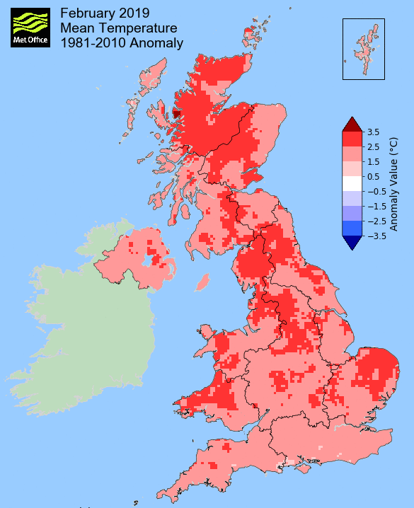
Exceptionably warm and marginally wetter than average - record breaking warmth with numerous days exceeding 15°c
It may surprise some that February 2019 is only the second warmest February recorded, especially with weather more akin to late spring being experienced late in the month, but despite this it did still manage to break a few records.
Whilst 1998 remains the warmest on record, this February did experience some incredibly high day-time temperatures. This saw the warmest February temperature record literally smashed and with it went the record for the highest monthly mean maximum temperature with some sites finishing with a mean maximum above 10°c - at times the temperatures were more akin to what would be expected in May.
The cold start to the month and cooler nights at the month's end saw the mean minimum temperature still way above average, but by a smaller margin. And with the warmer temperatures came plenty of sunshine (not something that Feb' 1998 could boast!) and provisionally this has also been the second sunniest February on record - that warmth and sunshine being simply glorious during the 22nd-27th when all apart from the 27th attained 15°c and both the 25-26th went all day without a cloud in the sky.
Overall the month did finish marginally wetter than average, although rainfall was mainly confined to the first ten days (80% of the month's rain fell in this time), thereafter only the 18-20th saw any meaningful rainfall.
The cold start to the month had seen snow from the end of January still laying on the ground for the first three days and there were some quite severe frosts in that time, but with the month finishing (locally) over 2.5°c above average, the early snow and cold was quickly forgotten.
MSLP of 1016.0 Mb was +2.1 Mb above the local average for the month and overall a mean minimum of 1.85°c and a mean maximum of 9.72°c saw the temperature 2.33°c above the ten year average for this site - it has been the warmest February yet recorded at this site. The highest maximum temperature recorded was 18.5°c (26th), the lowest minimum -8.2°c (3rd).
Rainfall of 90.3 mm (Crosby Ravensworth School 108.9 mm) was 102.1% of average for 2008-18 and made it the wettest February since 2016.
Of the twelve now recorded, eight have been drier and three have been wetter.
During the month, the following was recorded: snow fell on two days (1st and 3rd) and was laying on the ground (to a depth of least 1 cm at 0900 GMT) on three days.
At the Met' Office site at Newton Rigg, rainfall of 61.2 mm (82.4%) was the driest since 2015 and in a series back to 1900 February has been drier in 55 years and wetter in 63 years (1 year of no data).
A mean temperature of 6.20°c is 2.6°c above the average for 1981-2010 and makes this February the second warmest in the Newton Rigg record, 1998 being the warmest at a quite unbelievable 7.35°c - hard to believe that February 2019 is still over 1°c colder than 1998!
However, whilst only the second warmest in the record, its mean maximum temperature of 10.28°c for the month is the first time that 10°c as been recorded.
Locally, rainfall percentages tended to be below average outside of the Lake District, typically 70-80%, but within the National Park those averages shot up to as high as 146% at Seathwaite.
Figures from the Environment Agency�s rainfall sites were, (figure in brackets being the monthly average for 1961-90) �Data kindly provided by the Hydrometry and Telemetry team of the Environment Agency (Penrith)�:
Kirkby Thore 36.2 mm (48.7 mm)
Haresceugh Castle (Kirkoswald) 40.01 mm (56.6 mm)
Brothers Water 263.45 mm (192 mm) and
Orton (Shallowford) 145.0 mm ** (139.3 mm [average for 1967-2017])
397.6 mm at Seathwaite Farm (Borrowdale - 272 mm [average for 1981-2010]).
** estimate by myself due to a faulty gauge.
General Synoptic Report for the Month
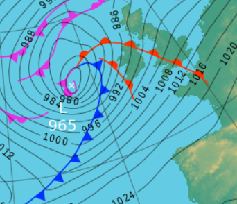
Under a northerly flow it was a cold start to the month, especially with snow left over from January still on the ground.
LP had moved into Biscay overnight into the 1st and this gave the N'ly flow down its western flank and following this the Azores high ridged north. Hard frosts resulted with a low of -7.7°c on the 1st and which with a maximum of just 1.9°c would become the month's coldest day. Whilst low pressure (LP) was never far away, the UK was either under the influence of that ridge of HP or in fairly slack gradient and consequently at night the skies tended to clear. This saw the month's coldest night fall 2nd/3rd, the 3rd starting with a low -8.2°c (27.2°f) and a ground frost of -11.1°c.
The snow that lay on the ground would last up to the 3rd after which the thaw came quite quickly.
The theme would now become one of a succession of LP systems arriving from the Atlantic bringing milder and wetter conditions, although with the occasional ridge of HP in between systems there were some brighter moments (Shap recorded 4.7 Hrs of sunshine on the 4th) - but this culminated in a particularly wet day on the 8th with the arrival of 'Storm Erik'.
The thaw on the 3rd came with the approach of LP from the west, initially having a little sleet/snow on its leading edge before turning to rain; wettest overnight into the 4th, giving 12.9 mm.
The 7th was a quiet day ahead of Erik which arrived overnight into the 8th. The night became wet and windy, this seeing 18.7 mm of rain credited back to the 7th and which continued, heavy at times, throughout the morning - with further rain overnight into the 9th this saw 25.6 mm of rain credited to the 8th. The wind was also a feature with numerous gusts over 50 Mph, peaking at 53 mph, the day itself averaging 19.9 Mph for the 24hrs.
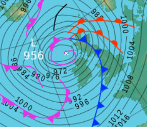
The 9th saw Erik clearing north but on its southern flank the wind remained strong and gusty, the maximum gust being 51 Mph, but the day itself did improve to one of sunny spells.
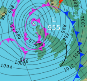
Initially from Biscay, HP would now build and become the dominant force for the rest of the month, but for the vast majority of the month that HP would sit over Europe (Germany/Austria), leaving the UK at its outer, western, edges and susceptible to the occasional front associated to LP in the Atlantic - more notably though was a steady increase in the temperature, accelerated later in the period by a prolonged southerly airflow that resulted in record temperatures for February.
Rainfall did become less frequent and lighter and apart from some ground frosts late in the period, there was no more frost.
It wasn't until the 14th that the temperature rose above 10°c and apart from a slight dip 18-20th, when a LP system tracked across the UK, there it remained. That LP brought the last meaningful rain of the month.
From the 22nd the weather could only be described as crazy - with maximum temperatures rising to a quite staggering 18.5°c (65.3°f); temperatures that would be classed as a warm day even towards the end of May!
But there was more to it than this - each day in the period of 22nd-26th saw the temperature climb above 15°c!
The 22nd at 16.4°c (17.4°c at Levens) had smashed the previous highest February temperature (12.7°c at Maulds Meaburn) and this new record would be broken again on the 25th (17.0°c) before the peak of the warmth on the 26th.
But then there was even more to it than this - the sunshine. From the 22nd the sun shone all day long and then the 26-27th did not see a cloud at all.
High pressure having built in Biscay migrated into Europe, remaining dominant and drawing up a very warm southerly airflow.
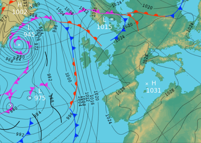
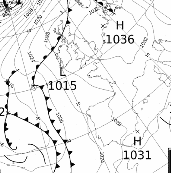
The 27th saw a dip in the temperature, but it was still warmer than the previous warmest day in February and then the month finished on a somewhat cooler and murky note as HP to the east of Iceland ridged down.
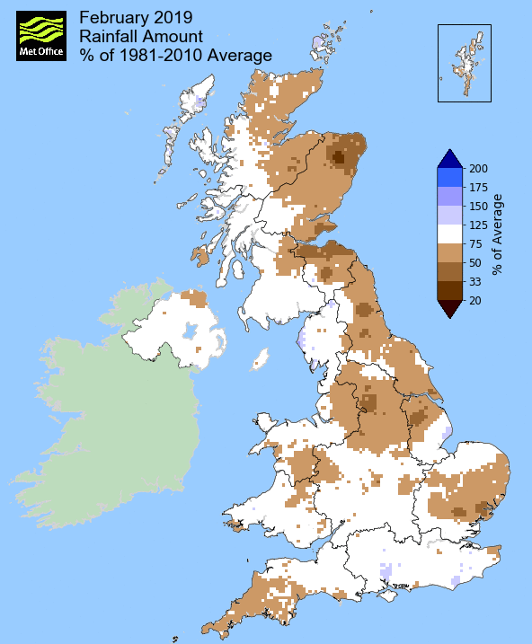
Rainfall totalled 90.3 mm for the month, with rain recorded on 16 days of which 11 were 'Wet days' (1.0mm +).
The Mean Temperature for the month was 5.78°c -- The Mean Max' was 9.72°c -- The Mean Min' 1.85°c.
We had 6 Air Frosts in the month (year 20) -- Grass frosts totalled 17 (year 37).
The 1 foot soil temp ranged from a low of 2.0°c on the 4th to a high of 6.9°c on the 24th -- with a monthly mean of 4.9°c
The 1 meter soil temp ranged from a low of 5.1°c on the 7th to a high of 7.0°c on the 25-27th -- with a monthly mean of 6.0°c
WINTER
Here at Maulds Meaburn the winter of 2018-19 just never really happened and that was despite the forecasters suggesting something cold following a 'Sudden stratospheric warming' (SSW) during December.
December did not even see a single flake of snow and February became incredibly warm with record breaking daily temperatures. Winter was confined to a very small corner of six days at the end of January and beginning of February. During this time snow that had fallen early on the 29th managed to hang about up to the 3rd and temperatures fell below -8.0°c on both the 31st and 3rd - and then that was it!
Here at Maulds Meaburn rainfall totalled 229.0 mm (Crosby Ravensworth 264.6 mm). This makes it the third driest (of 12) in my records and is 55.7% of the rainfall for those previous eleven winters.
A mean temperature of 4.62°c is the warmest since 2016-17 and the fourth warmest of the ten now recorded. It was 1.15°c warmer than the average of those previous nine winters.
At Newton Rigg rainfall totalled 178.0 mm and had a mean temperature of 4.86°c. In comparison to the 1981-2010 averages this represents 63.4% of winter rainfall and is 1.43°c warmer than average.
This makes the winter of 2018-19 the 21st driest in a series back to 1900-01 (3 yrs of missing data) and in a series back to 1953-54 it is the 7th warmest. In the much longer series back to 1914-15, but with 8 missing years, it would be the 8th warmest.
JANUARY 2010
FEBRUARY 2010
MARCH 2010
APRIL 2010
MAY 2010
JUNE 2010
JULY 2010
AUGUST 2010
SEPTEMBER 2010
OCTOBER 2010
NOVEMBER 2010
DECEMBER 2010
JANUARY 2011
FEBRUARY 2011
MARCH 2011
APRIL 2011
MAY 2011
JUNE 2011
JULY 2011
AUGUST 2011
SEPTEMBER 2011
OCTOBER 2011
NOVEMBER 2011
DECEMBER 2011
JANUARY 2012
FEBRUARY 2012
MARCH 2012
APRIL 2012
MAY 2012
JUNE 2012
JULY 2012
AUGUST 2012
SEPTEMBER 2012
OCTOBER 2012
NOVEMBER 2012
DECEMBER 2012
SUMMER 2012
REVIEW OF 2012
JANUARY 2013
FEBRUARY 2013
MARCH 2013
APRIL 2013
MAY 2013
JUNE 2013
JULY 2013
AUGUST 2013
SEPTEMBER 2013
OCTOBER 2013
NOVEMBER 2013
DECEMBER 2013
REVIEW OF 2013
JANUARY 2014
FEBRUARY 2014
MARCH 2014
APRIL 2014
MAY 2014
JUNE 2014
JULY 2014
AUGUST 2014
SEPTEMBER 2014
OCTOBER 2014
NOVEMBER 2014
DECEMBER 2014
WINTER 2014
REVIEW OF 2014
JANUARY 2015
FEBRUARY 2015
MARCH 2015
APRIL 2015
MAY 2015
JUNE 2015
JULY 2015
AUGUST 2015
SEPTEMBER 2015
OCTOBER 2015
NOVEMBER 2015
DECEMBER 2015
REVIEW OF 2015
JANUARY 2016
FEBRUARY 2016
MARCH 2016
APRIL 2016
MAY 2016
JUNE 2016
JULY 2016
AUGUST 2016
SEPTEMBER 2016
OCTOBER 2016
NOVEMBER 2016
DECEMBER 2016
REVIEW OF 2016
JANUARY 2017
FEBRUARY 2017
MARCH 2017
APRIL 2017
MAY 2017
JUNE 2017
JULY 2017
AUGUST 2017
SEPTEMBER 2017
OCTOBER 2017
NOVEMBER 2017
DECEMBER 2017
REVIEW OF 2017
JANUARY 2018
FEBRUARY 2018
MARCH 2018
APRIL 2018
MAY 2018
JUNE 2018
JULY 2018
AUGUST 2018
SEPTEMBER 2018
OCTOBER 2018
NOVEMBER 2018
DECEMBER 2018
REVIEW OF 2018
OTHER ARTICLES
The Oldest Inhabitant
An Inch Of Scotch Mist
But it's meant to be Summer (Summer 2017)
© Darren Rogers 2010-18
Want to comment on this site? email